![](/images/other/stat-length.png)
![Randonnée Cheval Gorges du Tarn Causses - Nissoulorgues-L'Hom - Photo](https://media.geolcdn.com/t/1900/400/ext.pjpeg?maxdim=2&url=https%3A%2F%2Fservices.sitytrail.com%2FGeolivesWS%2FDownloadMedia.ashx%3FTrailID%3D611034%26Media%3D20160808161545.jpg)
Nissoulorgues-L'Hom
alfreson
Utilisateur
![Longueur](/images/other/stat-length.png)
Longueur
28 km
![Altitude max](https://static1.geolcdn.com/siteimages/upload/files/1508320355ic_sort_altitude_max_24dp.png)
Altitude max
1169 m
![Dénivelé positif](https://static1.geolcdn.com/siteimages/upload/files/1508320355ic_sort_den_pos_24dp.png)
Dénivelé positif
939 m
![Km-Effort](/images/other/stat-length.png)
Km-Effort
40 km
![Altitude min](https://static1.geolcdn.com/siteimages/upload/files/1508320355ic_sort_altitude_min_24dp.png)
Altitude min
478 m
![Dénivelé négatif](https://static1.geolcdn.com/siteimages/upload/files/1508320355ic_sort_den_neg_24dp.png)
Dénivelé négatif
772 m
![Boucle](https://static1.geolcdn.com/siteimages/upload/files/16400158638029165_repeat_loop_refresh_sync_direction_icon.png)
Boucle
Non
Date de création :
2016-08-08 00:00:00.0
Dernière modification :
2016-08-08 00:00:00.0
![Cheval](https://static1.geolcdn.com/sitytour/trail-icons/300.png)
5h14
Difficulté : Facile
![Scannez ce code QR pour ouvrir la randonnée dans l'application SityTrail](https://capi.geolives.com/qq0zvz2zws4bq2lad0pu/sitytour/trails/611034/qr.png?size=200)
Application GPS de randonnée GRATUITE
À propos
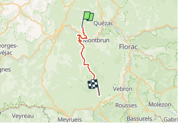
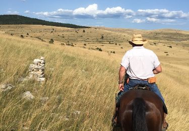
Randonnée Cheval de 28 km à découvrir à Occitanie, Lozère, Gorges du Tarn Causses. Cette randonnée est proposée par alfreson.
Description
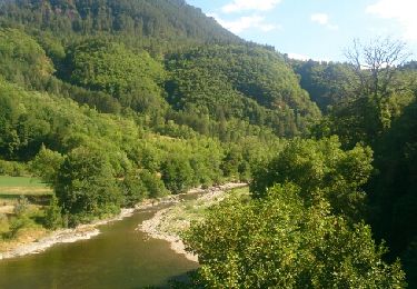
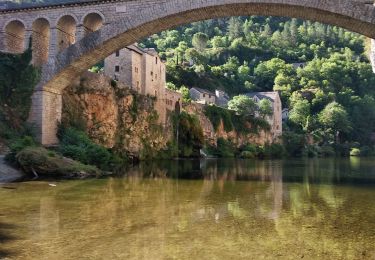
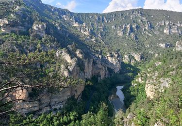
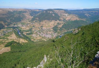
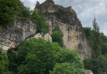
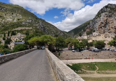
Les hauteurs du Tarn avec la Causse Sauveterre, la traversée du Tarn, des pinèdes et garrigues, puis la Causse Méjean et le Chaos du Vieux Nîmes, avec deux très beaux galops dans les bois puis dans la Causse...
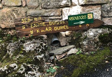
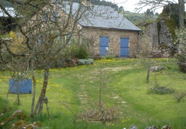
Localisation
Pays :
France
Région :
Occitanie
Département/Province :
Lozère
Commune :
Gorges du Tarn Causses
Localité :
Sainte-Enimie
Départ:(Dec)
Départ:(UTM)
537055 ; 4912171 (31T) N.
Commentaires
Randonnées à proximité
![Randonnée Marche Ispagnac - Ispagnac et Quezac - Photo](https://media.geolcdn.com/t/375/260/ext.jpg?maxdim=2&url=https%3A%2F%2Fservices.sitytrail.com%2FGeolivesWS%2FDownloadMedia.ashx%3FTrailID%3D449646%26Media%3Dfix__20150725172954.jpg)
![Marche Marche](https://static1.geolcdn.com/sitytour/trail-icons/101.png)
Ispagnac et Quezac
Marche
Facile
(2)
Ispagnac,
Occitanie,
Lozère,
France
![](/images/other/stat-length.png)
8,8 km | 12,5 km-effort
2h 22min
![](https://static1.geolcdn.com/siteimages/upload/files/16400158638029165_repeat_loop_refresh_sync_direction_icon.png)
Oui
![Randonnée Marche Gorges du Tarn Causses - ste enimie - la Malene - Photo](https://media.geolcdn.com/t/375/260/eb08616c-72b6-43fb-8af1-e2907fa3fc92.jpg&format=jpg&maxdim=2)
![Marche Marche](https://static1.geolcdn.com/sitytour/trail-icons/101.png)
ste enimie - la Malene
Marche
Facile
Gorges du Tarn Causses,
Occitanie,
Lozère,
France
![](/images/other/stat-length.png)
15,9 km | 22 km-effort
4h 36min
![](https://static1.geolcdn.com/siteimages/upload/files/16400158638029165_repeat_loop_refresh_sync_direction_icon.png)
Non
![Randonnée Marche Gorges du Tarn Causses - Ste Enimie, le Boisset - Photo](https://media.geolcdn.com/t/375/260/c8e7aa0f-2f81-400e-a6dd-e67c5f500e2c.jpg&format=jpg&maxdim=2)
![Marche Marche](https://static1.geolcdn.com/sitytour/trail-icons/101.png)
Ste Enimie, le Boisset
Marche
Moyen
Gorges du Tarn Causses,
Occitanie,
Lozère,
France
![](/images/other/stat-length.png)
8,4 km | 14,6 km-effort
2h 33min
![](https://static1.geolcdn.com/siteimages/upload/files/16400158638029165_repeat_loop_refresh_sync_direction_icon.png)
Oui
![Randonnée Marche Gorges du Tarn Causses - Au long du Tarn: de St Enimie aux Vignes - Photo](https://media.geolcdn.com/t/375/260/a97cde4c-beef-4feb-8a60-28696a762de5.jpg&format=jpg&maxdim=2)
![Marche Marche](https://static1.geolcdn.com/sitytour/trail-icons/101.png)
Au long du Tarn: de St Enimie aux Vignes
Marche
Très difficile
Gorges du Tarn Causses,
Occitanie,
Lozère,
France
![](/images/other/stat-length.png)
28 km | 39 km-effort
8h 54min
![](https://static1.geolcdn.com/siteimages/upload/files/16400158638029165_repeat_loop_refresh_sync_direction_icon.png)
Non
![Randonnée Marche Gorges du Tarn Causses - La Condamine, le Single - Photo](https://media.geolcdn.com/t/375/260/6f6c90a3-3ef1-4c96-a33d-def6a7dcdb4c.jpg&format=jpg&maxdim=2)
![Marche Marche](https://static1.geolcdn.com/sitytour/trail-icons/101.png)
La Condamine, le Single
Marche
Facile
Gorges du Tarn Causses,
Occitanie,
Lozère,
France
![](/images/other/stat-length.png)
11,3 km | 14,8 km-effort
3h 15min
![](https://static1.geolcdn.com/siteimages/upload/files/16400158638029165_repeat_loop_refresh_sync_direction_icon.png)
Oui
![Randonnée Marche Gorges du Tarn Causses - Sainte enfiliez - Photo](https://media.geolcdn.com/t/375/260/41e52d00-94cc-4ebf-9b85-13a630ee5b38.jpg&format=jpg&maxdim=2)
![Marche Marche](https://static1.geolcdn.com/sitytour/trail-icons/101.png)
Sainte enfiliez
Marche
Moyen
Gorges du Tarn Causses,
Occitanie,
Lozère,
France
![](/images/other/stat-length.png)
17 km | 22 km-effort
4h 36min
![](https://static1.geolcdn.com/siteimages/upload/files/16400158638029165_repeat_loop_refresh_sync_direction_icon.png)
Oui
![Randonnée Marche Gorges du Tarn Causses - Tour du Causse Méjean - Etape 1 - Photo](https://media.geolcdn.com/t/375/260/ext.jpg?maxdim=2&url=https%3A%2F%2Fservices.sitytrail.com%2FGeolivesWS%2FDownloadMedia.ashx%3FTrailID%3D1037411%26Media%3Dfix__20180831135516.jpg)
![Marche Marche](https://static1.geolcdn.com/sitytour/trail-icons/101.png)
Tour du Causse Méjean - Etape 1
Marche
Facile
Gorges du Tarn Causses,
Occitanie,
Lozère,
France
![](/images/other/stat-length.png)
15,5 km | 22 km-effort
4h 36min
![](https://static1.geolcdn.com/siteimages/upload/files/16400158638029165_repeat_loop_refresh_sync_direction_icon.png)
Non
![Randonnée Cheval Gorges du Tarn Causses - Nissoulorgues-L'Hom - Photo](https://media.geolcdn.com/t/375/260/ext.jpg?maxdim=2&url=https%3A%2F%2Fservices.sitytrail.com%2FGeolivesWS%2FDownloadMedia.ashx%3FTrailID%3D809149%26Media%3D20160808171741.jpg)
![Cheval Cheval](https://static1.geolcdn.com/sitytour/trail-icons/300.png)
Nissoulorgues-L'Hom
Cheval
Facile
Gorges du Tarn Causses,
Occitanie,
Lozère,
France
![](/images/other/stat-length.png)
28 km | 40 km-effort
5h 14min
![](https://static1.geolcdn.com/siteimages/upload/files/16400158638029165_repeat_loop_refresh_sync_direction_icon.png)
Non
![Randonnée Marche Gorges du Tarn Causses - Gorges du Tarn Est 4 jours - Photo](https://media.geolcdn.com/t/375/260/ext.jpg?maxdim=2&url=https%3A%2F%2Fservices.sitytrail.com%2FGeolivesWS%2FDownloadMedia.ashx%3FTrailID%3D560760%26Media%3Dde2ab5b7-4353-46cf-9d7f-823225efd7e0.JPG)
![Marche Marche](https://static1.geolcdn.com/sitytour/trail-icons/101.png)
Gorges du Tarn Est 4 jours
Marche
Moyen
Gorges du Tarn Causses,
Occitanie,
Lozère,
France
![](/images/other/stat-length.png)
65 km | 90 km-effort
18h 52min
![](https://static1.geolcdn.com/siteimages/upload/files/16400158638029165_repeat_loop_refresh_sync_direction_icon.png)
Oui